Aller au contenu principal
Webcam
23°C
Accessibilité
en
Menu
To see, to do
The mountain pros
Winter activities
Alpine skiing - Ski touring
Nordic skiing
Snowshoeing - Nordic walking
Luge-Snake gliss-Snow tubing
Sled dogs and company
Unusual and thrilling
Ski schools
Skis club-Snow club-Snow kite
Daycare
Rent your equipment
Transportation to stations
Walks and hikes
Hiking alone
Itinerant hiking
Hiking with a guide
On 2 wheels
With 6 legs
Car and motorcycle tours
Maps and topos
To discover
Prehistory and caves
Cultural heritage
Cultural leisure
Visit
Industrial visits
See animals
Natural sites
Thermalism and well-being
Spa treatments
Wellness
Mini-treatments
Spa discovery day
Tasting
Restaurants
Local products
Markets
Get out
Agenda
The must-sees
Have a drink
Play at the Casino
Going to the movies
Summer activities
In the air
In the water
Underground
With animals
In ski resorts
Leisure facilities
Sleep
A real estate agency with a black and white sign indicating 'IMMOBILIER'. The windows are filled with real estate listings. There is snow on the ground and on the roof of the agency. A yellow sign is visible to the right of the entrance.
©
The real estate agency attracts customers with its prominently displayed listings.
estate agencies
A tent and a car are set up in a countryside campsite. In the background, imposing mountains rise under a clear sky. Several other tents and vehicles are visible nearby.
©
A peaceful campsite surrounded by majestic mountains.
campsites and motorhome parks
The bedroom features a double bed with a wicker headboard, a green blanket, and two bedside lamps. A window with gray curtains lets in natural light. A wicker basket and a small nightstand complete the space.
©
An inviting bedroom with touches of nature and comfort.
bed & breakfast
A wooden house with orange shutters is situated on a green hillside. The house is surrounded by trees and lush vegetation. The sky is clear and blue, and the house appears to be a peaceful and secluded place.
©
A secluded wooden house surrounded by trees.
gîtes d’étapes and inns
A stone cabin with a grass roof, a wooden door, and a window decorated with flowers. Two white deck chairs and a wooden bench are placed on the grass in front of the cabin. The sky is clear and the sun is shining.
©
A peaceful relaxation spot in front of a rustic stone cabin.
unusual accommodation
An elegant manor with intricate architectural details and a large garden. The facade is painted white with yellow accents and dark wood elements. The manor has several windows and balconies, as well as a sloping roof with dormer windows. The garden is well-maintained with neatly trimmed trees and bushes.
©
An elegant manor with intricate architectural details and a large garden.
Hotels
This image depicts a modern rustic interior with a fully equipped kitchen and a comfortable living room. Exposed wooden beams and stone walls create a warm atmosphere. The living room features a sofa with black cushions and a throw blanket, along with a wooden coffee table. The kitchen is equipped with modern appliances and a central island.
©
A perfect blend of wood and stone for a warm and inviting interior.
Vacation rentals
View of a modern and bright interior with an open kitchen and living room. The kitchen is equipped with a stainless steel sink, a wooden countertop, and several white cabinets. The living room includes a gray sofa, two green chairs, and a wooden coffee table. The walls are decorated with drawings and text, and the floor is made of light wood.
©
A modern and bright interior with an open kitchen and a welcoming living room.
label ax vacation rentals
An isolated mountain refuge stands on a hill, surrounded by mountainous landscapes and a lake below. The refuge is brown with a gray roof, and it is surrounded by vegetation. The sky is blue with a few scattered clouds.
©
An isolated mountain refuge offers a breathtaking view of the surrounding landscapes.
forest refuges and lodges
A modern living room with gray tiled flooring and white walls. A central stone fireplace with a large metal flue rises in the middle of the room. There are two sofas, one white and one brown, as well as several wooden armchairs with leaf patterns. A television is mounted on the right wall. The room is well-lit with several lamps and a large window in the background.
©
A spacious and elegant living room with an imposing central fireplace.
tourist homes
The room features a double bed with a red cover and beige pillows. Red and white curtains frame a large window offering a view of the mountains. A small teddy bear sits on the bed. To the right, there is a wooden chair with a cushion and a wooden nightstand with various items.
©
A cozy room with a breathtaking view of the mountains.
vacation villages and resorts
The bedroom features a double bed with white linens and matching pillows. The walls are exposed stone, and the wooden ceiling adds a warm touch. A large window lets in natural light, and a colorful rug adds a cozy feel. Wooden furniture and decorative accessories complete the rustic ambiance.
©
A warm and inviting bedroom with a comfortable bed and rustic decor.
all accommodations
Practice
View of an artisan shop with wooden shelves filled with various local products. The products are neatly arranged, with jars of jam, bottles of wine, and other artisanal items. The shop is well-lit and has a cozy atmosphere.
©
A cozy shop where local products are showcased.
shops
The stone building has a modern facade with large glass windows. There are accessibility signs visible on the facade, indicating facilities adapted for people with disabilities. The building is located in an urban area with trees and mountains in the background.
©
A stone building with a modern facade and accessibility signs.
services
The wooden house features a large wooden terrace with neatly aligned planks. The shutters of the windows are closed and painted black. The roof structure is visible and made of wood, with exposed beams. The house is surrounded by green trees and the sky is clear.
©
A modern wooden house with a spacious terrace and closed shutters.
Artisans
Tourist Office
Our info points
A team to advise you
Quality approach
Satisfaction survey
Praticals advices
Let's be responsible!
Packing your suitcase
Avoiding disaster plans
Questions / Answers
To come, to move
How to get here
Getting around
How to get to Andorra
Info route
Webcams
GROUPS
Book
Home
Things to see and do
Walks and hikes
La tour de Montorgueil
La tour de Montorgueil
Sport
Pedestrian sports
Hiking itinerary
Elevation : 649m
Parking du Calamès de Bédeilhac, 09400 Bédeilhac-et-Aynat
Getting there
×
Open the itinerary in
Google Maps
Apple Plans
Waze
Mappy
Share
×
Share this sheet
La tour de Montorgueil
E-mail
WhatsApp
Facebook
X
LinkedIn
Pinterest
©
Mairie de Saurat
©
Mairie de Saurat
×
©
Mairie de Saurat
©
Mairie de Saurat
Services
Car park
Animals accepted
View all services
×
Equipment
Car park
Services
Pets welcome
Documentation
La tour de Montorgueil
Environment
Mountain location
Village 2 km away
Less than 10 minutes from a train station by car
10 - 20 min from a train station by bike
10 - 20 min from an SNCF station by electric bike
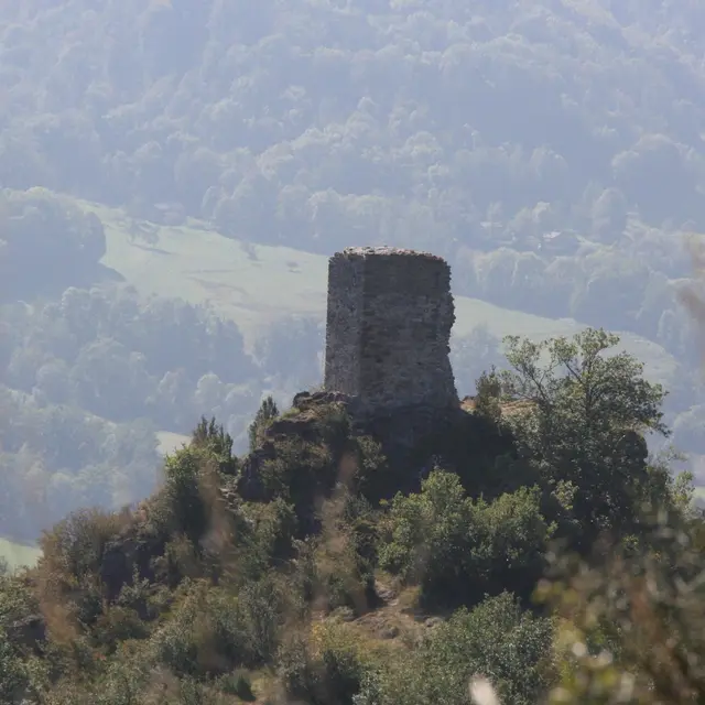
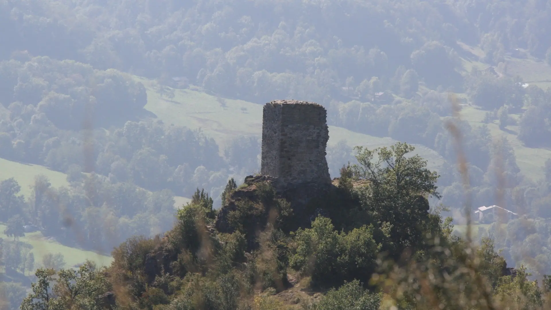
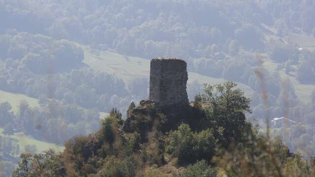
The Montorgueil tower
This castle belonging to the Counts of Foix was probably built in the late 12th or early 13th century, when the Counts regained control of the Saurat valley.
Bédeilhac-et-Aynat
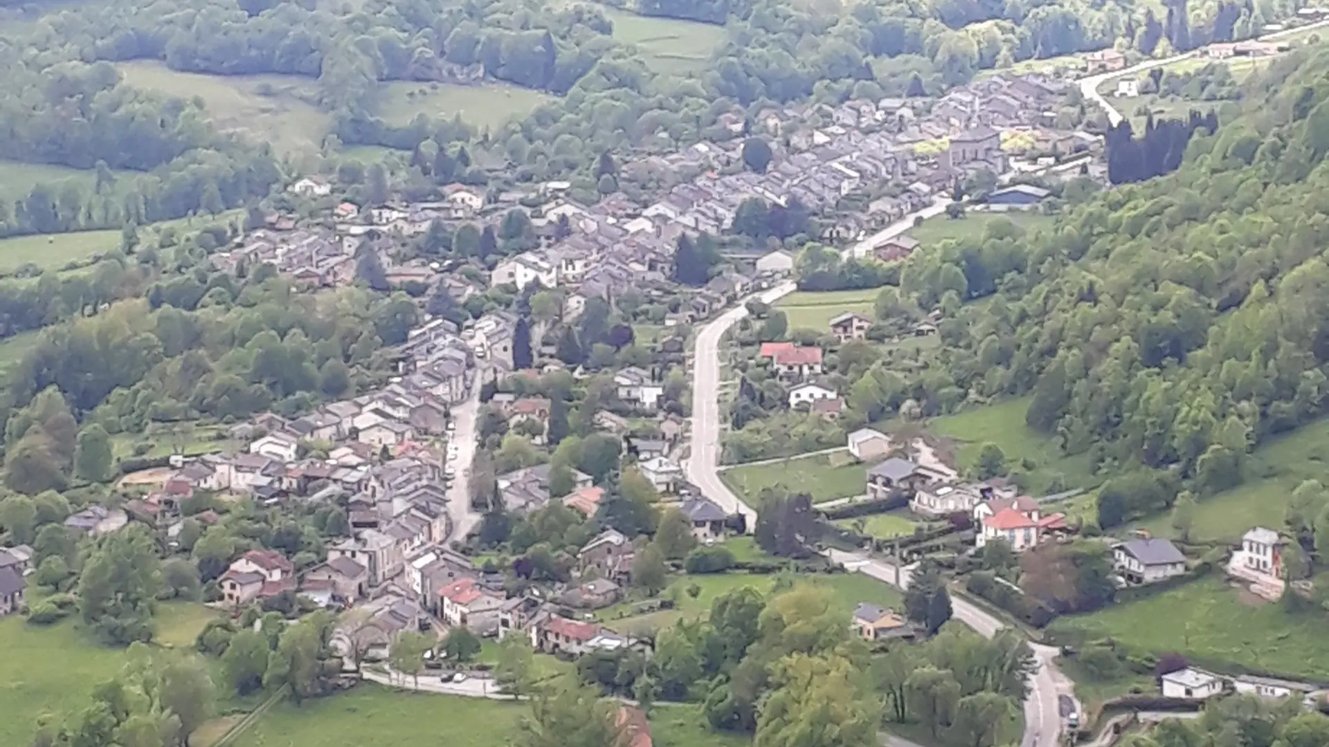
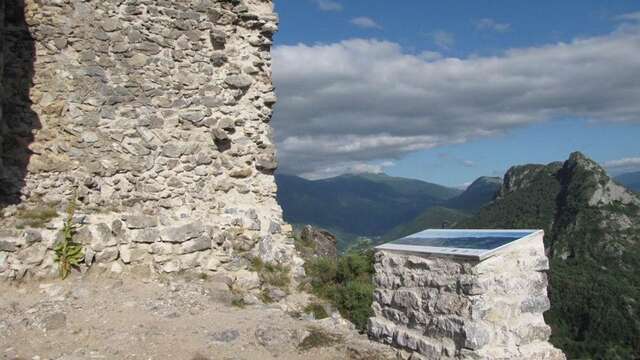
Montorgueil Tower orientation table
At an altitude of 865 m, at the foot of the Montorgueil tower, an orientation table offers a panoramic view of the village of Saurat and the valleys below.
Bédeilhac-et-Aynat
Close
Popular searches
{% label %}
Filter search
Page types
All
Articles
Agenda
Lists
Aucun résultat
/
English
Français
Español
Close
×